
OMODEI MINING ENTERPRISES
BN 18862986
Resources Exploration, Mining, Infrastructure & Development

Whispering Ridge -
and Drilling to December 2010
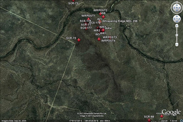
Whispering Ridge main surface Iron ore body at Anomaly "Zone A" MDL 298
and Anomaly "Zone B" EPM 15896 Location Map
In evaluating an anomaly outside the "Zone A" area, it was found to be exceptionally jarositic (also highly weathered). The results of this rock type are strongly anomalous in Cu, Fe Ni, Sc, V, Zn and moderately anomalous in As, Bi, Co, Cr, Mo. The presence of anomalous Co, Ni and Cr indicate a deep fluid source.
Accurate terrain data collected from SAM Survey Results to show detail DEM comparing work at between MDL 298 and EPM 15896 overlaid on Google Earth Image Boundary-
An overlay of drilling holes and sampling Zones A and B at Whispering Ridge compared to Google by ground elevation from GPS acquired as part of Sub Audio Magnetics survey captured by Gap Geophysics
WRD #3 RC Drill Hole Pad and Rig Zone A
WRD #4 RC Drill Hole Pad and Rig Zone A
WRD #6 RC Drill Hole Pad and Rig Zone A
WRD #6 RC Drill Hole Pad and Rig Zone A
JH #1 RC Drill Hole Pad and Rig Zone B
JH #1 RC Drill Hole Pad and Rig Zone B
History and Summary of Pertinent Minerals Exploration Work Surrounding MDL298 which was Accomplished by Previous Holders
From the Shell/BHPB aerial surveys, the Whispering Ridge high grade magnetite outcrops are very subtle; whereas, they can’t be seen on the magnetic contour maps, the ore exists as a large body of magnetite with polarisation points vertical. The December 2009 RC drilling shows it continues to depth in a southwest direction; further step back drilling will define the true depth and size. The Gap Geophysics Australia Pty Ltd sub-
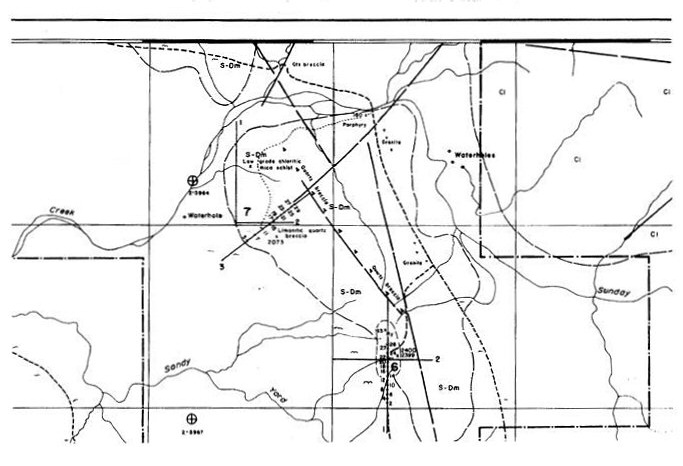
Shell Australia was exploring for tin and tungsten, not iron. However, from the individual RAB hole drilling data showing “Geological description/information and samples collected by Pilbara Labs”; the magnetic susceptibility was described at each hole by anomaly as reported by them in 1982. Susceptibility readings to a depth of 7 metres reached as high as 600 in Anomaly 6 and to a depth of 24 meters as high as 450 in Anomaly 7. Further detailed evaluation of these works is being carried out in order to redrill these anomalies to depth for iron, together with the Shell drilling north of Sunday creek and to the west of Boeing and Conical hills.
Extract of Shell Targets 6 and 7 surrounding the Whispering Ridge area from the Shell Company of Australia Limited, Metals Division from QDEX records 11601 Sheet No. 2 detailing geology of Sunday Creek including location of RAB drilling holes completed in 1982.
WHISPERING RIDGE MAGNETITE
PROJECT MDL 298


Access and Export
Logistics
to date 2010
Access and Export
Logistics
to date 2008
Whispering Ridge
Site Pictures, Rock Sample Results and Drilling to Dec 2010
Queensland Department
of Mines and Energy granted
permanent road access 2008
Access and Export
Logistics
to date 2007
Sub Audio Magnetics
over Whispering Ridge and
Sunday Creek from 2007
Mobilisation and product
road access
alternatives for
Whispering Ridge and Sunday Creek
exploration and mining leases 2007
Whispering Ridge
(MDL 298) and Sunday Creek (EPM 15896) Exploration Update
To June 2014
to December 2010
Whispering Ridge
(MDL 298) and Sunday Creek (EPM 15896) Magnetite Deposits -
to December 2013
Access and Export
Logistics
to date 2014
Whispering Ridge
Site Pictures, Rock Sample Results and Drilling to date 2008
Access and Export
Logistics
to date 2005
Background Exploration
History -
Tenement Areas
Location Map -
and
Grid Locations
Whispering Ridge
(MDL 298) and Sunday Creek (EPM 15896) Exploration Update
To June 2017
to December 2010
Access and Export
Logistics
to date 2017